Navigation

![]()

![]()
.png)
Pagami Creek Fire Severity Study
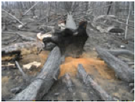 The
Pagami Creek Fire burned over 38,000 ha (94,000 ac) of the Boundary Waters
Canoe Area Wilderness in northern Minnesota, but presented a unique research
opportunity. A decade of remote sensing efforts in the region provided
pre-fire information unprecedented in its level of detail. Our research
team therefore initiated a rapid field research and remote sensing campaign
to apply hyperspectral imagery to scale fire severity (understory and
overstory) and loss of soil element emissions (carbon, nitrogen, and mercury)
to the full extent of this fire event. Our research will establish a baseline
of initial impacts at high resolution and large extent for a fire of regional
importance in a location where pre-fire forest conditions were well-documented.
The
Pagami Creek Fire burned over 38,000 ha (94,000 ac) of the Boundary Waters
Canoe Area Wilderness in northern Minnesota, but presented a unique research
opportunity. A decade of remote sensing efforts in the region provided
pre-fire information unprecedented in its level of detail. Our research
team therefore initiated a rapid field research and remote sensing campaign
to apply hyperspectral imagery to scale fire severity (understory and
overstory) and loss of soil element emissions (carbon, nitrogen, and mercury)
to the full extent of this fire event. Our research will establish a baseline
of initial impacts at high resolution and large extent for a fire of regional
importance in a location where pre-fire forest conditions were well-documented.
For more information, contact Brian Sturtevant, USFS Northern Research
Station (bsturtevant@fs.fed.us)
or visit http://nrs.fs.fed.us/disturbance/fire/extreme_fire_effects_mn/.
Also, recall the Superior National Forest Mercury Fire Effects Study and the webinar entitled Wildland Fire and Mercury Contamination in Soil and Water presented by Randy Kolka (USFS Northern Research Station) and Trent Wickman (USFS Air Quality) last year.